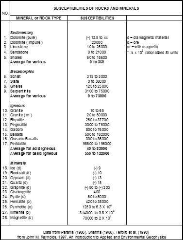
The material containing magnetic minerals can be induced by the earth's magnetic field, so that spatial variations of the magnetic field can be used to predict the presence of marine cables, pipes, or any dangerous metal object that submerged in water and can become an obstacle for infrastructure development in the survey area. Table 1 shows the value of rock susceptibility in nature:
Table 1. Rock Susceptibility Value.
Diurnal Correction needs to be done to eliminate the diurnal variation of the magnetic field of the earth. To get an accurate gamma value, the diurnal variation calculation should be done continuously by using magnetometers at the base station:
Zdc = Zr - DC
where:
Zdc : The magnetic measurement results that are corrected by daily variation of the magnetic values
Zr : the magnetic value measurement results
DC : diurnal correction
Drift correction is applied to eliminate the effect of hovering on the instrument. This correction comes from double checking of tools at the base station at appropriate time intervals. After the drift correction is done on ZDC, magnetic intensity will be obtained at each point (Zobs) obtained. Normal Correction (NC) is applied to eliminate the effect of earth magnetic field variations around the region due to variations in gravity with latitude. In normal correction. Base Correction (MBC) is applied to eliminate the magnetic value of the magnetic base station. This is done by reducing the value of gravity. Therefore, the corrected intensity of the total magnetic end (CZ) is:
CZ = Zobs - NC - MBC
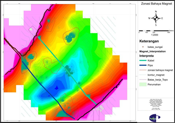
Magnetic Contour
Man-made objects to be detected in marine geomagnet, will be high magnetic values, this is caused by the material content that is easier to induce than the surrounding rocks. Examples of magnetic data and interpretation of the work can be seen in the following figure:
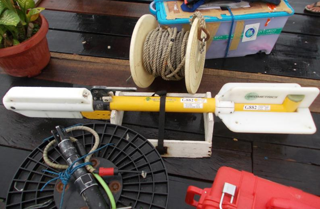
The image below shows Marine Geomagnet (Geometrics G882) and ground geomagnet (GEM-Sys 19T) tools that used to measure the daily magnetic variation values at survey location.
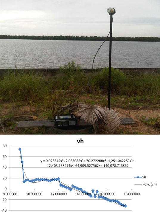
Marine magnetic survey can be carried out simultaneously with Batimetry surveys. This Magnetometer Survey should have a diurnal variation correction, then measured the earth's magnetic field on the ground (base station). GEM-Sys 19T and hourly magnetic value for one day in exactly same location. Furthermore, the magnetic anomaly data found in the survey will be plotted on the bathymetry map. Data processing methods should include corrections that should produce good results.