 Side Scan Sonar (SSS) is a marine survey equipment system that uses acoustic technology.
This tool is used to mapping the seafloor that can also be used to study life on the seabed.
This equipment system is a sensing strategy for recording seabed conditions by utilizing the properties
of seafloor media capable of emitting, reflecting and / or absorbing sound waves. Sound waves used in
side scan sonar technology usually have frequencies between 100 and 500 KHz. The wave pulse is emitted
in a wide angle pattern toward the seafloor, and the echo is received back by the receiver in seconds.
To search for a particular location, the recording needs to follow a particular survey path pattern
using GPS positioning equipment and plotter video. Side scan sonar able to create coverage of seabed
recording from both sides of the survey path. In calm sea conditions and a straight ship's bow,
the sonogram can provide a very sharp and detailed image or image just like a photograph.
Side Scan Sonar (SSS) is a marine survey equipment system that uses acoustic technology.
This tool is used to mapping the seafloor that can also be used to study life on the seabed.
This equipment system is a sensing strategy for recording seabed conditions by utilizing the properties
of seafloor media capable of emitting, reflecting and / or absorbing sound waves. Sound waves used in
side scan sonar technology usually have frequencies between 100 and 500 KHz. The wave pulse is emitted
in a wide angle pattern toward the seafloor, and the echo is received back by the receiver in seconds.
To search for a particular location, the recording needs to follow a particular survey path pattern
using GPS positioning equipment and plotter video. Side scan sonar able to create coverage of seabed
recording from both sides of the survey path. In calm sea conditions and a straight ship's bow,
the sonogram can provide a very sharp and detailed image or image just like a photograph.
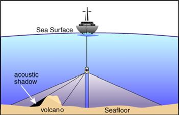
Side scan sonar transducer system is stored in a towfish that is towed by the ship several desimeters
below sea level. The reflected sound wave is processed into an image that resembles an aerial photograph,
and seen real-time on a computer monitor. Location information from DGPS (differential global positioning
system) is used to guide the side scan sonar along a predetermined lane, as well as to identify the location
of various points on the side scan image. Figure 1 below shows how SSS is used.
Another use of side scan sonar is to detect extraction location sea sand aggregate. On a detailed scale can
also be used to find submarine cables and pipelines, even shipwreck. The advantage of using side scan sonar
is its ability to search for underwater objects on a large area quickly and safely. Divers have low risk
during operations, and are only involved when the underwater object has been discovered. Side scan sonar
image is also useful for evaluating various underwater dangers against divers before they enter the water.
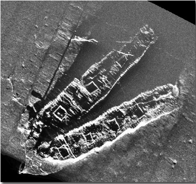
An example of side scan sonar image can be seen in Figure below from Frank A. Palmer and Louise B.Crary.
(Courtesy of NOAA/SBNMS and NURC-Uconn).
Dual-channel Side Scan Sonar System has a minimum range coverage capability of up to 75 m used to obtain
seabed features along the same corridor as Batimetry survey. The sweeping scale used is arranged in such
a way that there is a minimum overlap of 50% for the planned survey area.
The side scan side sonar survey can be running simultaneously with the implementation of the Batimetric
survey and / or adjusted to the depth of the sea so that the minimum coverage can be met. The possibility
of any danger or condition of the seabed that needs special attention should be investigated to clarify
the type and size of the hazard. The investigation can be carried out by running a more densely lane in
a different direction than the previous common lane.
Positioning using a certain distance or time must be marked on the sonar record. The distance data between
the towfish and the GPS antenna, including any changes to this distance, should be recorded in an orderly
manner at the Operator's Log during the survey for further data processing. This SSS data will be used as
a reference during the interpretation and evaluation / analysis of the sub-bottom profiler recording data.
Indication of recorded hazards, will then be plotted on the bathymetry map. The results of this interpretation
will also be correlated with the results of Magnetometer interpretation.