 According to Poerbandono and Djunarsjah (2005), Bathymetry survey is a process and activity aimed
at obtaining the seabed surface (model) surface shape (topography).
The basic depiction of the waters (from measurement, processing to visualization) is referred to as
bathymetry survey. The main purpose of bathymetry survey is safety of navigation. One method of
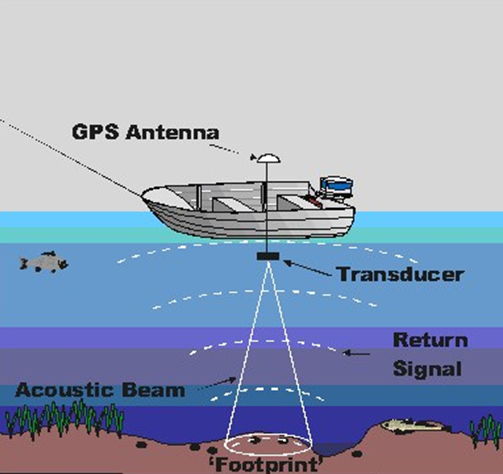
measuring the depth of the ocean is by acoustic method (Figure below taken from
http://www.ozcoasts.gov.au/glossary/def_s-t.jsp) using an echosounder.
The echo device will produce an acoustic wave with a certain frequency that allows to penetrate
a certain medium, in this case water. In the acoustic method the electrical energy is transformed
into mechanical energy in the form of sound waves. Sound waves are emitted through the transducer,
reflected by the seafloor and will be received back by the tranducer.
According to Poerbandono and Djunarsjah (2005), Bathymetry survey is a process and activity aimed
at obtaining the seabed surface (model) surface shape (topography).
The basic depiction of the waters (from measurement, processing to visualization) is referred to as
bathymetry survey. The main purpose of bathymetry survey is safety of navigation. One method of
measuring the depth of the ocean is by acoustic method (Figure below taken from
http://www.ozcoasts.gov.au/glossary/def_s-t.jsp) using an echosounder.
The echo device will produce an acoustic wave with a certain frequency that allows to penetrate
a certain medium, in this case water. In the acoustic method the electrical energy is transformed
into mechanical energy in the form of sound waves. Sound waves are emitted through the transducer,
reflected by the seafloor and will be received back by the tranducer.
Principles calculations on the depth of the acoustic method is to calculate the time interval since
the waves emitted and received back due to reflection by the bottom waters. The time interval is then
multiplied by the velocity of acoustic waves in a water medium. The measurement results are displayed
in the form of depth lines in the echogram and / or in digital form. Storage and appearance in digital
form using navigation software capable of being integrated with measurement positions. Bathymetry survey
begins with the manufacture of survey lines. The lanes are measured in depth and represented in the form of
depth points. Each measured point has time, position, and depth variables. Position can be obtained by
integrating echosounder with satellite navigation technology.
 In bathymetry survey there are basic provisions that must be implemented.
The provisions are made by the International Hydrographic Organization (IHO) published
in the form of Special Publication Number 44 (SP-44 IHO) 5th Edition of 2008.
The provisions in SP-44 IHO include:
In bathymetry survey there are basic provisions that must be implemented.
The provisions are made by the International Hydrographic Organization (IHO) published
in the form of Special Publication Number 44 (SP-44 IHO) 5th Edition of 2008.
The provisions in SP-44 IHO include:
IHO classifies the level of accuracy of surveys through the order. Determination of order based on
topography of waters. Special Order is aimed at locations with marine waters that are hazardous to the
safety of shipping, Order 1a is used for locations less than 100 m deep and less dangerous for shipping,
Order 1b is used for locations less than 100 m deep and not harmful to safety cruises, and Order 2 for
locations with a depth of more than 100 m.
The position of the measured depth points refers to the ITRF geocentric reference frame and preferably
using WGS84. The confidence level of the position is determined at 95%. Each Order of accuracy survey
has its own criteria in determining horizontal accuracy.
Depth value less than 200 m should be corrected against tidal. In addition, any object found during
the survey and considered to interfere with the safety of shipping shall be reported to its position
and depth.