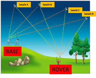
 GPS Real-Time Kinematic (GPS RTK) is one of the data acquisition methods to get the coordinate position on the earth's surface
(as well as the elevation) by using GPS (Global Positioning System).
It requires a minimum of 2 sets of GPS Instruments.
One set served as a base station as a correction at the benchmark (BM) known coordinate,
and another set as a rover or working GPS at the planned point location to gain coordinate for.
GPS Real-Time Kinematic (GPS RTK) is one of the data acquisition methods to get the coordinate position on the earth's surface
(as well as the elevation) by using GPS (Global Positioning System).
It requires a minimum of 2 sets of GPS Instruments.
One set served as a base station as a correction at the benchmark (BM) known coordinate,
and another set as a rover or working GPS at the planned point location to gain coordinate for.
RTK method is effective for positioning surveys with good accuracy of up to 1 cm.
To get maximum accuracy of the coordinates, GPS (Base and Rover) must be stationed at the wide-angle area of the canopy.
The distance between base and rover must be close to each other as 20 km to speed up measurement time.
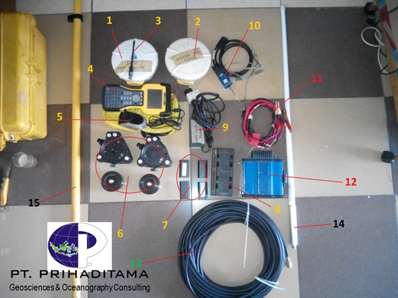 Equipment for GPS-RTK Survey
1. GPS Trimble 5700 (base)
2. GPS Trimble 5700 (rover)
3. Small GPS Antenna
4. Trimble Controller
5. AC Adapter
6. Tribach
7. Trimble Lithium-ion Battery
8. Trimble Battery Charger
9. AC Adapter
10.RS Cable
11.Radio to Battery Connector
12.Positioning Data Link (PDL) Radio Antenna
13.Antenna Cable
14.External Antenna
15.GPS Rover Stick