Ocean tide is a phenomenon of ups and downs of sea water accompanied by the
horizontal movement of water mass periodically due to the attraction of celestial bodies, especially
the moon and sun. Period of ups and downs of sea water about 12.4 hours and 24.8 hours.
To understand the phenomenon of tide, we can use the theory of equilibrium tide.
The theory of tidal equilibrium begins with the assumption that the earth is round and
completely covered by the sea. The sea responds to the moon's gravity which is the closest
celestial body to the earth. The gravitational force of the moon will be offset by
the centrifugal force that occurs due to the rotation of the earth.
The resin between the moon's gravitational force and the centrifugal force of the earth will
form the tidal equilibrium which results in the presence of two low-tide and two high-tide
places on earth.
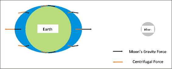
Figure 1. Tide Equilibrium.
The tide will experience a maximum height when the earth-solar-moon system in the parallel direction (new and full moon), hereinafter referred to as spring tide. While the tide will experience the lowest height when the earth-sun-moon system is perpendicular to each other (the quarter of the initial month and quarter of the last month), hereinafter referred to as the neap tide. Tidal measured is the sum of the components of the result of tidal pull of celestial objects. Based on its constituent components, the tides can be classified into four types through Formzahl number calculations:F = (K1+O1) / (M2+S2)
where:
K1 : Moon and Sun Declination system with 23.93 hour periode
O1 : Moon Decllination with 25.82 hours periode
M2 : Gravity of the moon with a circular orbit and parallel to the earth equator with a period of 12.42 hours
S2 : Gravity of the sun with a circular orbit and parallel to the earth equator with a period of 12 hours
1. Diurnal Tide (F is more than 3)
In diurnal tides high and low water positions occur only once in one day of observation.
2. Mixed tide lean to diurnal ( F between 1,5 & 3)
Mixed tide lean to diurnal is a combination of diurnal and semidiurnal tides. Sometimes within a day it only takes one tide and follows the maximum declination of the moon and sometimes also two high tides and the time interval between the transit months and the rising tide is very different.
3. Mixed tide lean to semidiurnal (F between 0,25 & 1,5)
Mixed tide lean to semidiurnal is a combination of diurnal and semidiurnal tides. In a day there will be two tide cycles but the height and moon transit period and rising tide are not the same.
4. Semidiurnal Tide (F is less than 0,25)
In the semidiurnal tide, tidal waves occur as much as two cycles in one day of observation so that it will get twice the position of high and low water level.
The tides can be observed in three ways (Poerbandono and Djunarsjah, 2005):
1. Manual observation
Manual observation is done by making palm / tidal signs equipped with tape measure. The height of the palm is adjusted by the tidal riding of the waters observed and established in a static and open place. It is intended that the palm will not collapse when crashing currents or sea waves and facilitate the observer to record the water level. Recording of sea level changes is done with a certain time interval (usually every 1 hour).
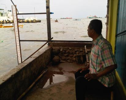
Figure 2. Manual Tidal Measurement.
2. Automatic ObservationAutomatic observation allows tides to be observed without the use of human labor. bservations automatically divided into mechanical observation by using tide gauge or digital (Tide Master) which uses acoustic or optical sensors.
3. Satellite
Manual and automatic observations are made for local scale and close to the beach. Satellite technology allows humans to observe tides that are far from shore with regional and global scale. Topex / Poseidon altimetry satellites are satellites capable of observing sea levels with the help of RADAR pulses.
Observation of tide is done for at least 15 days. Recording of tidal height is done every 1 hour, but if the observation is done simultaneously with batimetry survey then the water level is recorded every 10 minutes. It aims to obtain optimum results at the time of the tidal correction on bathymetric data.
The height of the tidal observation station with the benchmark should be measured using a waterpass tool. This measurement method is called the leveling survey. An example of the leveling measurement is described in the following figure:
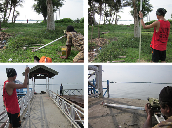
Figure 3. Levelling Survey.
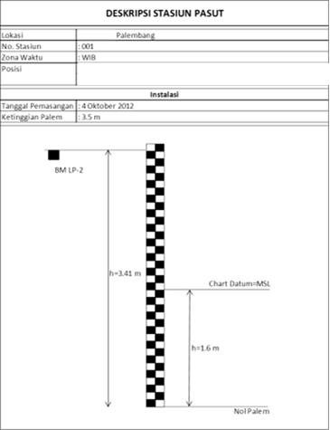
Figure 4. Tide Palm Description.