The city of Bandung is one of the largest and most important cities in Indonesia. The city has a long and interesting history, from prehistoric times to the present
day. Around 500,000 years ago, the city of Bandung was a giant lake called Lake Bandung Purba. This lake was formed due to the large eruption of Mount Sunda Purba
and formed the Sunda Caldera. The water in this lake began to recede around 16,000 years ago after the eruptions of Mount Tangkuban Parahu. The Cikahuripan -
Cukangrahong - Halimun Waterfall area was damaged by an earthquake and landslide.
The city of Bandung was founded by the 9th Bandung Regent, R.A. Wiranatakusumah II (1794-1829), known as Dalem Kaum. He led the clearing of forest on vacant land on
the west bank of the Cikapundung River and the south bank of Jalan Raya Pos (now Jalan Asia Afrika) to become the new capital of Bandung Regency which was previously
in Krapyak (now Dayeuhkolot). The development of this city was accelerated by orders from the Governor General of the Dutch East Indies, Herman Willem Daendels
(1808-1811), who wanted to make it easier to access the regent's office.
The city of Bandung received the nickname Paris van Java which was first popularized by a French journalist named Louis Couperus in 1922 because of the beauty and
progress of this city during the Dutch colonial period such as the Merdeka Building (now the Museum of the Asian-African Conference), Gedung Sate (now the Office
of the Governor of Java). West), Villa Isola (now the University of Education of Indonesia), and Hotel Savoy Homann (now Hotel Savoy Homann Bidakara). The city
became a center for plantations, trade, education, and recreation for Dutch officials and businessmen.
The beautiful view of Bandung city, which used to be called Paris van Java, is now slightly disturbed by the electric cables sticking out in the air. Apart from
destroying the aesthetics of the city, these cables also have the potential to pose a danger to the community. To overcome this, the Bandung City Government
(Pemkot) has started implementing a ducting system, namely the removal of underground utility cables.
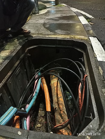
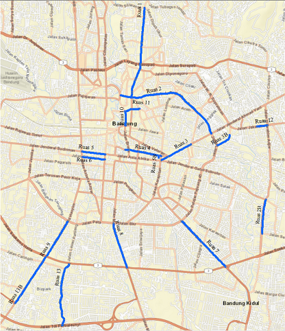
This ducting system is already available on 13 roads in the city of Bandung, including Jalan Ir. H. Djuanda, Jalan RE. Martadinata, Jalan Ahmad Yani, Jalan Naripan,
Jalan Sudirman, Jalan Cibadak, Jalan Buahbatu, Jalan Moch Toha, Jalan Kopo, Jalan Wastukancana, Jalan Aceh, Jalan Jakarta and Jalan Cibaduyut.
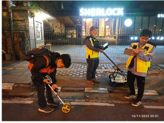
One of the stages before lowering the cable needs to be clarified in advance whether the available underground ducting is connected and integrated. Detection of
underground ducting installations made of concrete can be identified using Georadar or GPR instruments.
Georadar or GPR (abbreviation of Ground Penetrating Radar) method is a geophysical method that utilizes electromagnetic (EM) waves in response to the reflectivity
properties (reflectance) of a material. The EM waves emitted from a radar transmitter, through an interface (boundary) between two mediums (rock, concrete, water,
metal, etc.) have different values of physical properties. Then the EM wave is reflected back and recorded by the receiver as a subsurface picture signal and can
be observed directly on the display monitor of the Digital Control Unit.