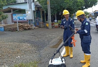
PT. Prihaditama has rewarded for Georadar/GPR Project in Cilacap. The project purpose is to locating buried underground pipeline belonging to Pertamina Cilacap by using the GPR Mala El Core 450 Mhz. The project team successfully located all the pipelines that were around 3 meters underground and detected the dimension and depth of the foundation.
GPRtechnology is very useful for surveying underground infrastructure such as pipe, cable, dimension and size of the building
foundation. The use of GPR technology is an excellent example of non-destructive testing methods that are becoming increasingly important in the field of infrastructure surveying. Non-destructive
testing reduces the need for excavation and minimizes disruptions to the environment. Additionally, it can save time and money in the long run, making it a cost-effective option for infrastructure
surveying.
GPR technology works by emitting electromagnetic waves that penetrate the ground and bounce back when they encounter an object or change in soil composition. By analyzing the reflected waves,
GPR systems can create a detailed map of the subsurface, allowing for the identification and location of buried infrastructure.
To ensure the reliability of the GPR data that collected by project team. The GPR team doing a quality control by conducting multiple scans and comparing results between every line GPR that
acquired in the Cilacap Field to compare every anomaly in every line of the GPR.
The data collected by GPR Technology can be used to make a reliable decisions about infrastructure maintenance, repair, and replacement of underground pipe. By identifying the location of the
buried underground pipe, the owner of the pipe can be use to prevent accidental damage during excavation or new construction above the pipeline.
The completion of the GPR Projects in Cilacap has demonstrated effectiveness and efficiency of GPR technology to identify buried infrastructure that buried like pipelines, cables, and foundation
of the bridge. This non-destructive test is a very useful to minimize any disruption in environment, reducing cost, and improve safety of the future infrastructure projects in the survey area.